Jump to content

Nyhellervatnet - Sogn og Fjordane 1.0.0

   (1 review)

2 Screenshots

About This File

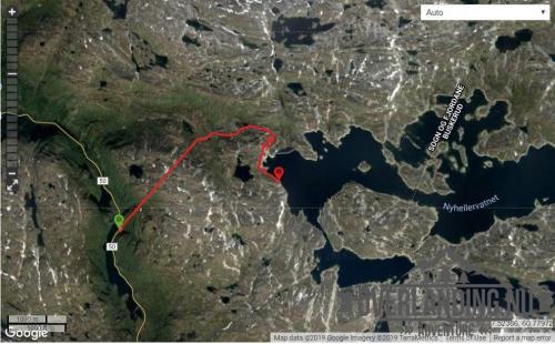
Another short (8km) utility road in the Aurland II hydro power plant system, but with a twist - a dark and steep 3km tunnel through the mountain from FV50. The tunnel starts at 1050m asl and exits at 1250m, before the final section towards and Nyhellervatnet at and around 1450m. There is no lighting in the tunnel! 

It's a good place to pack a Zodiac. 5 years  have passed since I visited, but this track should still be current and.

This road and tunnel was also to bring materials and machinery into the Aurland II hydro power plant system, and a prerequisite for the aproval to the project was that the roads would be open to the public after the project completed. Most other hydro power plant developments in Norway was not subject to the same requirement for open utility roads, and these roads are usually closed or have limited access.

  • Like 2
 Share


User Feedback

You may only provide a review once you have downloaded the file.


blackstream

· Edited by blackstream

   4 of 4 members found this review helpful 4 / 4 members

Vägen stängd sommar-hösten 2019 pga byggarbeten. 

Vägen är avstängd med grind/bom. Vi va där söndag 21/7—19 kl11. 

20190721_105726.jpg

Response from the author:

Men den er ikke permanent stengt tror jeg? Dette er hentet fra e-co sine hjemmesider.


Åpningstider veg Nyheller sommer 2019

Det skal transporteres stein til dam Vetlebotn. Av hensyn til trafikksikkerhet for allmennheten vil anleggsvei bli stengt med bom ved Finndalstunnel i det tidsrom det foregår transport av stein.

Fra torsdag 27. juni kl. 20:00 vil vegtrasé åpnes for allmenheten i følgende tidsrom:

  • Hverdager: 11 – 12:00 og fra 20:00 til 06:30 neste dag
  • Helger: Fra torsdag kl.20:00 til mandag morgen kl.06:30
  • Like 2
Link to review
×
×
  • Create New...