

Pokerfjes
-
Posts
28 -
Joined
-
Last visited
-
Days Won
3
Content Type
Profiles
Forums
Downloads
Butik
Gallery
Files posted by Pokerfjes
-
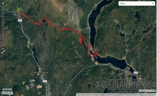
Eggedal-Noresund - Buskerud
This 30km route is a mountain road between Eggedal and Noresund which at it highest elevation is just below the treeline.
The first half of the route is mostly gravel and the second half is mostly paved. It is a two lane road.
This is a toll road, but it is also open during wintertime. Second half of the route goes through the cabin villages connected to Norefjell skisenter.
I extended the route to end at Eventyrmuseet Villa Fridheim, a 100-year old museum in swiss and dragon style. You can't really camp anywhere along the route, but there are plenty of roads spawning off this which will take you to parking just in the treeline, where you can camp and/or hike into the mountains. Gråfjell (1466m asl), Ranten (1417m asl) and Høgevard (1457m asl) are popular destinations starting from Tempelseter or Norefjell Skisenter. From Høgevarde, on a clear day, you can see as much as 40.000 m2 of mainland Norway - only surpassed by the view from Gaustatoppen.
16 downloads
(0 reviews)0 comments
Submitted
-
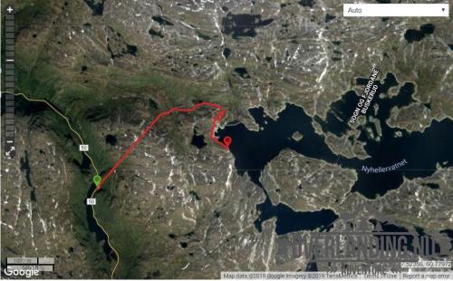
Nyhellervatnet - Sogn og Fjordane
Another short (8km) utility road in the Aurland II hydro power plant system, but with a twist - a dark and steep 3km tunnel through the mountain from FV50. The tunnel starts at 1050m asl and exits at 1250m, before the final section towards and Nyhellervatnet at and around 1450m. There is no lighting in the tunnel!
It's a good place to pack a Zodiac. 5 years have passed since I visited, but this track should still be current and.
This road and tunnel was also to bring materials and machinery into the Aurland II hydro power plant system, and a prerequisite for the aproval to the project was that the roads would be open to the public after the project completed. Most other hydro power plant developments in Norway was not subject to the same requirement for open utility roads, and these roads are usually closed or have limited access.
14 downloads
- aurland
- sogn og fjordane
- (and 2 more)
(1 review)0 comments
Submitted
-
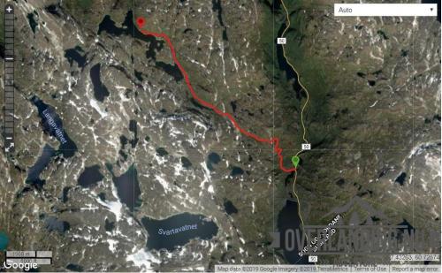
Katlavatnet - Sogn og Fjordane
A short (8.5km) gravel road from FV50 to Katlavatnet. The track starts at about 1100 metres asl and up to 1400m. The road is narrow but runs through a rather open area after the first hills. Camping is possible along most of the track.
The road was built to bring materials and machinery into the Aurland II hydro power plant system, and a prerequisite for the aproval to the project was that the roads would be open to the public after the project completed.
8 downloads
- aurland
- sogn og fjordane
- (and 2 more)
(0 reviews)0 comments
Submitted
-
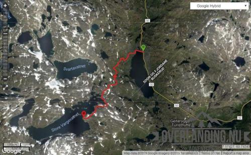
Store Vargevatnet - Sogn og Fjordane
This is a short (8km) but unusual gravel road from FV50 to Store Vargevatnet. Unusual in the sense that it is one of the few roads I know of where you can drive (toll-free!) from 1150 metres above sea level to nearly 1500m. The road is narrow, and during the high season - be aware of camper vans and other not so suited vehicles.
Camping is possible along most of the track, and the amount of possible hiking trips in the area is extensive, including a couple of small glaciers.
The road was built to bring materials and machinery into the Aurland II hydro power plant system, and a prerequisite for the aproval to the project was that the roads would be open to the public after the project completed.
11 downloads
- aurland
- sogn og fjordane
- (and 2 more)
(0 reviews)0 comments
Updated