Search the Community
Showing results for tags 'grus'.
Found 8 results
-
Version 1.0.0
14 downloads
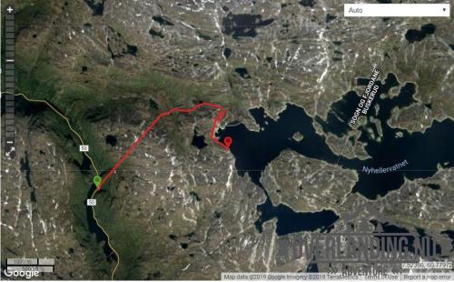
Another short (8km) utility road in the Aurland II hydro power plant system, but with a twist - a dark and steep 3km tunnel through the mountain from FV50. The tunnel starts at 1050m asl and exits at 1250m, before the final section towards and Nyhellervatnet at and around 1450m. There is no lighting in the tunnel! It's a good place to pack a Zodiac. 5 years have passed since I visited, but this track should still be current and. This road and tunnel was also to bring materials and machinery into the Aurland II hydro power plant system, and a prerequisite for the aproval to the project was that the roads would be open to the public after the project completed. Most other hydro power plant developments in Norway was not subject to the same requirement for open utility roads, and these roads are usually closed or have limited access.- 1 review
-
- 2
-

-
- aurland
- sogn og fjordane
- (and 2 more)
-
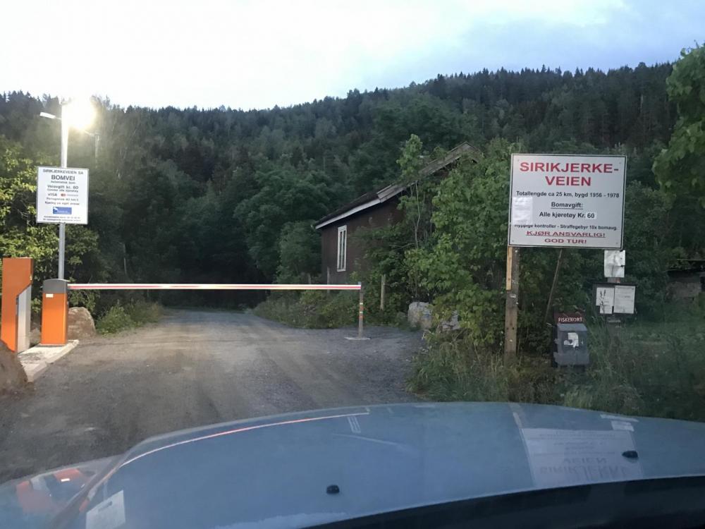
This is an alternative gravel road from Hagatjern to Vestfossen (or the other way around). By Norwegian measures, this isn't much of a scenic road, but there are viewpoints, and it's possible to get fairly close to Sirikjerke, which is the tallest mountain in Nedre Eiker county. Along the road, there are numerous small roads splitting off from the main - like logging roads. There is also a larger split breaking off south that I believe is posted here previously (Konnerud), but that is a detour now. Still - it's a few kilometers long, and there are a few nice fishing waters in the area - so it's worth taking a look. The road max min elevation is 36/412 meters, and Sirikjerke sits at 635 meters. If you are passing through the area, it's a great alternative to tarmac, and there are many options for a quick camping stop and/or hiking. It's a toll road, with a rate of 60NOK (card payment only), and as far as I could tell, a note at the toll booth says the entire road is not guaranteed to be cleared for snow during winter. However, that could mean that it's not implicitly closed and illegal to drive ther during winter - like many other similar roads. sirikjerkeveien-v1.gpx
-
View File Nyhellervatnet - Sogn og Fjordane Another short (8km) utility road in the Aurland II hydro power plant system, but with a twist - a dark and steep 3km tunnel through the mountain from FV50. The tunnel starts at 1050m asl and exits at 1250m, before the final section towards and Nyhellervatnet at and around 1450m. There is no lighting in the tunnel! It's a good place to pack a Zodiac. 5 years have passed since I visited, but this track should still be current and. This road and tunnel was also to bring materials and machinery into the Aurland II hydro power plant system, and a prerequisite for the aproval to the project was that the roads would be open to the public after the project completed. Most other hydro power plant developments in Norway was not subject to the same requirement for open utility roads, and these roads are usually closed or have limited access. Submitter Pokerfjes Submitted 01/04/2019 Category Norge
-
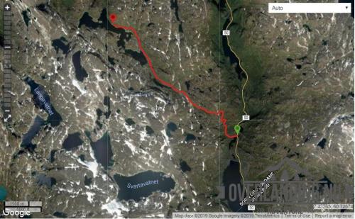
View File Katlavatnet - Sogn og Fjordane A short (8.5km) gravel road from FV50 to Katlavatnet. The track starts at about 1100 metres asl and up to 1400m. The road is narrow but runs through a rather open area after the first hills. Camping is possible along most of the track. The road was built to bring materials and machinery into the Aurland II hydro power plant system, and a prerequisite for the aproval to the project was that the roads would be open to the public after the project completed. Submitter Pokerfjes Submitted 01/04/2019 Category Norge
-
Version 1.0.0
8 downloads
A short (8.5km) gravel road from FV50 to Katlavatnet. The track starts at about 1100 metres asl and up to 1400m. The road is narrow but runs through a rather open area after the first hills. Camping is possible along most of the track. The road was built to bring materials and machinery into the Aurland II hydro power plant system, and a prerequisite for the aproval to the project was that the roads would be open to the public after the project completed. -
Version 1.0.0
11 downloads
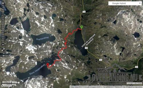
This is a short (8km) but unusual gravel road from FV50 to Store Vargevatnet. Unusual in the sense that it is one of the few roads I know of where you can drive (toll-free!) from 1150 metres above sea level to nearly 1500m. The road is narrow, and during the high season - be aware of camper vans and other not so suited vehicles. Camping is possible along most of the track, and the amount of possible hiking trips in the area is extensive, including a couple of small glaciers. The road was built to bring materials and machinery into the Aurland II hydro power plant system, and a prerequisite for the aproval to the project was that the roads would be open to the public after the project completed.-
- 1
-
-
- aurland
- sogn og fjordane
- (and 2 more)
-
View File Store Vargevatnet - Sogn og Fjordane This is a short (8km) but unusual gravel road from FV50 to Store Vargevatnet. Unusual in the sense that it is one of the few roads I know of where you can drive (toll-free!) from 1150 metres above sea level to nearly 1500m. The road is narrow, and during the high season - be aware of camper vans and other not so suited vehicles. Camping is possible along most of the track, and the amount of possible hiking trips in the area is extensive, including a couple of small glaciers. The road was built to bring materials and machinery into the Aurland II hydro power plant system, and a prerequisite for the aproval to the project was that the roads would be open to the public after the project completed. Submitter Pokerfjes Submitted 01/04/2019 Category Norge
-
- 1
-
-
- aurland
- sogn og fjordane
- (and 2 more)
-
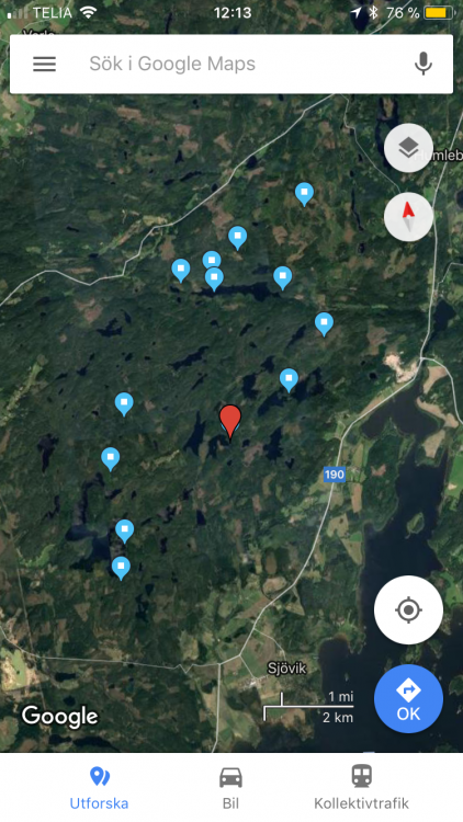
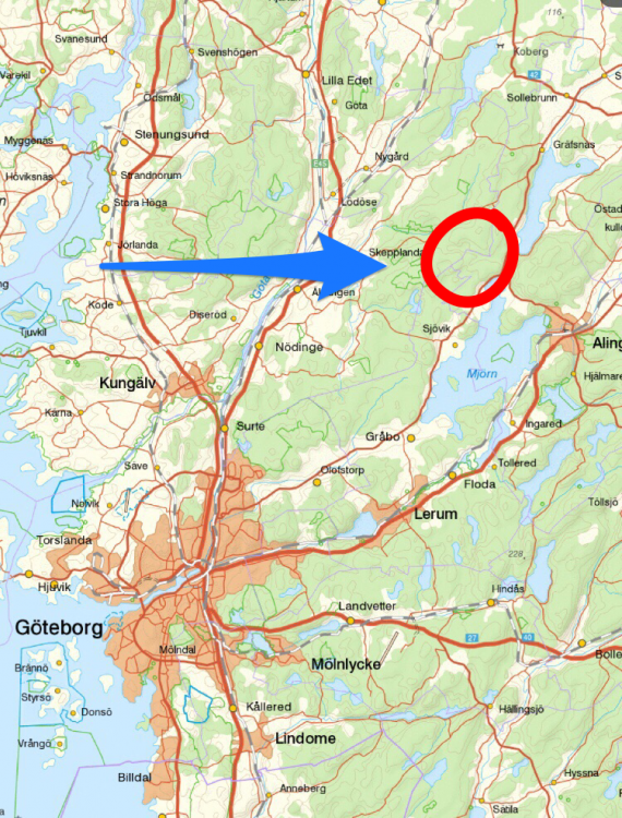
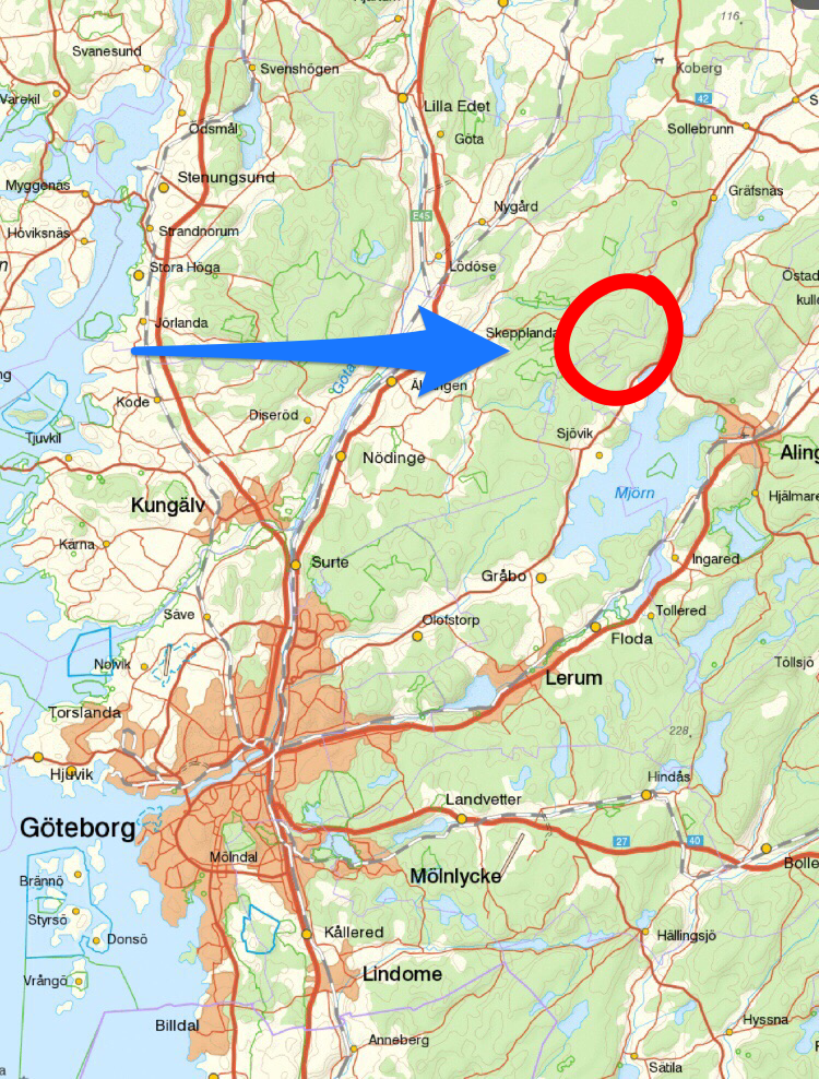
Tänkte mig ut i skogen o reka tältplatser, grillplatser och allmänna grusvägar i frisk luft kommande helg, 17/2. Finns intresse att hänga på och sparka däck? Ses gärna o tar med grillen/Muurikkan denna lördag. Kanske ett par timmar mitt på dagen Utöver att bekanta mig med vägar o skog kände jag att min GoPro kan ge mig material till att testa video/fotoredigering i min nya digitala hemmamiljö ? Gjort en radikal förändring i upplägget med hantering o lagring - Going Dropbox, all in Som sagt, en enkel tur denna dag