Search the Community
Showing results for tags 'sogn og fjordane'.
Found 10 results
-
Version 1.0.0
14 downloads
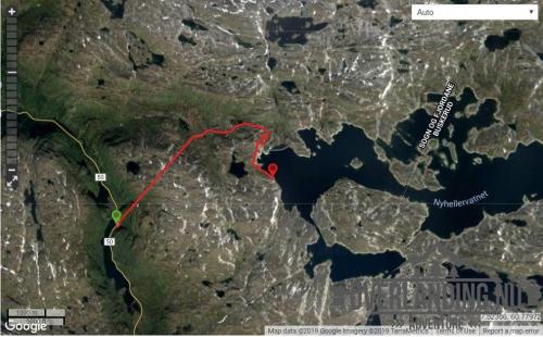
Another short (8km) utility road in the Aurland II hydro power plant system, but with a twist - a dark and steep 3km tunnel through the mountain from FV50. The tunnel starts at 1050m asl and exits at 1250m, before the final section towards and Nyhellervatnet at and around 1450m. There is no lighting in the tunnel! It's a good place to pack a Zodiac. 5 years have passed since I visited, but this track should still be current and. This road and tunnel was also to bring materials and machinery into the Aurland II hydro power plant system, and a prerequisite for the aproval to the project was that the roads would be open to the public after the project completed. Most other hydro power plant developments in Norway was not subject to the same requirement for open utility roads, and these roads are usually closed or have limited access.- 1 review
-
- 2
-

-
- aurland
- sogn og fjordane
- (and 2 more)
-
View File Nyhellervatnet - Sogn og Fjordane Another short (8km) utility road in the Aurland II hydro power plant system, but with a twist - a dark and steep 3km tunnel through the mountain from FV50. The tunnel starts at 1050m asl and exits at 1250m, before the final section towards and Nyhellervatnet at and around 1450m. There is no lighting in the tunnel! It's a good place to pack a Zodiac. 5 years have passed since I visited, but this track should still be current and. This road and tunnel was also to bring materials and machinery into the Aurland II hydro power plant system, and a prerequisite for the aproval to the project was that the roads would be open to the public after the project completed. Most other hydro power plant developments in Norway was not subject to the same requirement for open utility roads, and these roads are usually closed or have limited access. Submitter Pokerfjes Submitted 01/04/2019 Category Norge
-
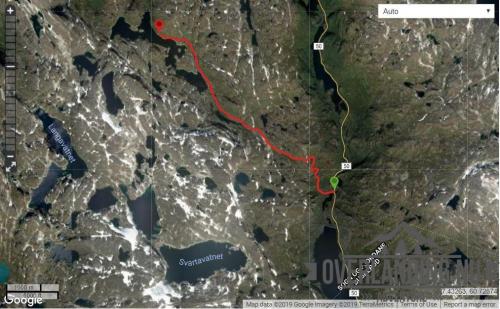
View File Katlavatnet - Sogn og Fjordane A short (8.5km) gravel road from FV50 to Katlavatnet. The track starts at about 1100 metres asl and up to 1400m. The road is narrow but runs through a rather open area after the first hills. Camping is possible along most of the track. The road was built to bring materials and machinery into the Aurland II hydro power plant system, and a prerequisite for the aproval to the project was that the roads would be open to the public after the project completed. Submitter Pokerfjes Submitted 01/04/2019 Category Norge
-
Version 1.0.0
8 downloads
A short (8.5km) gravel road from FV50 to Katlavatnet. The track starts at about 1100 metres asl and up to 1400m. The road is narrow but runs through a rather open area after the first hills. Camping is possible along most of the track. The road was built to bring materials and machinery into the Aurland II hydro power plant system, and a prerequisite for the aproval to the project was that the roads would be open to the public after the project completed. -
Version 1.0.0
11 downloads
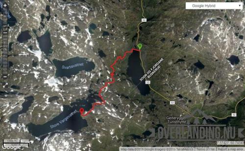
This is a short (8km) but unusual gravel road from FV50 to Store Vargevatnet. Unusual in the sense that it is one of the few roads I know of where you can drive (toll-free!) from 1150 metres above sea level to nearly 1500m. The road is narrow, and during the high season - be aware of camper vans and other not so suited vehicles. Camping is possible along most of the track, and the amount of possible hiking trips in the area is extensive, including a couple of small glaciers. The road was built to bring materials and machinery into the Aurland II hydro power plant system, and a prerequisite for the aproval to the project was that the roads would be open to the public after the project completed.-
- 1
-
-
- aurland
- sogn og fjordane
- (and 2 more)
-
View File Store Vargevatnet - Sogn og Fjordane This is a short (8km) but unusual gravel road from FV50 to Store Vargevatnet. Unusual in the sense that it is one of the few roads I know of where you can drive (toll-free!) from 1150 metres above sea level to nearly 1500m. The road is narrow, and during the high season - be aware of camper vans and other not so suited vehicles. Camping is possible along most of the track, and the amount of possible hiking trips in the area is extensive, including a couple of small glaciers. The road was built to bring materials and machinery into the Aurland II hydro power plant system, and a prerequisite for the aproval to the project was that the roads would be open to the public after the project completed. Submitter Pokerfjes Submitted 01/04/2019 Category Norge
-
- 1
-
-
- aurland
- sogn og fjordane
- (and 2 more)
-
Version 1.0.0
18 downloads
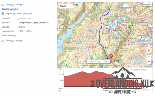
Om Tindevegen: Tindevegen er fjellvegen mellom Årdal og Turtagrø (32 km) som tek deg frå Sognefjorden til Jotunheimen. Fjellvegen er kalla ”snarvegen gjennom Jotunheimen”, og er kortaste alternativ frå Bergen til Trondheim. Og ferjefritt! Ein turistveg som knyter Årdal saman med Luster og Sognefjellsvegen (nasjonal turistveg). Fjellvegen går gjennom mektig natur blandt vakre toppar i Jotunheimen, med mange flotte utsiktspunkt. Ein kort spasertur frå traseen, ligg eit fantastisk panorama med Hurrungane og Store Skagastølstind i aust og Sognefjorden og Skjolden i vest. Tindevegen er ein bomveg for MC, bilar, bilar med campingvogn og bubilar (anbefalt maks 10 meter). Normalt ope frå mai til november. Sesongtrafikken er no vel 30000 kjøretøy. Läs mer på: http://www.tindevegen.no -
View File Tindevegen - Sogn og Fjordane Om Tindevegen: Tindevegen er fjellvegen mellom Årdal og Turtagrø (32 km) som tek deg frå Sognefjorden til Jotunheimen. Fjellvegen er kalla ”snarvegen gjennom Jotunheimen”, og er kortaste alternativ frå Bergen til Trondheim. Og ferjefritt! Ein turistveg som knyter Årdal saman med Luster og Sognefjellsvegen (nasjonal turistveg). Fjellvegen går gjennom mektig natur blandt vakre toppar i Jotunheimen, med mange flotte utsiktspunkt. Ein kort spasertur frå traseen, ligg eit fantastisk panorama med Hurrungane og Store Skagastølstind i aust og Sognefjorden og Skjolden i vest. Tindevegen er ein bomveg for MC, bilar, bilar med campingvogn og bubilar (anbefalt maks 10 meter). Normalt ope frå mai til november. Sesongtrafikken er no vel 30000 kjøretøy. Läs mer på: http://www.tindevegen.no Submitter Andreas.E Submitted 04. juli 2016 Category Norge
-
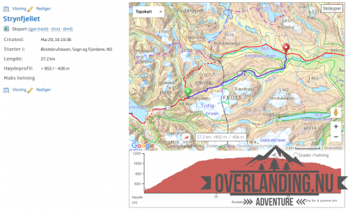
View File Strynfjellet - Sogn og Fjordane Ett kort men vacker spår som tar dig över Strynfjellet. På spåret passerar du sommarskidor anläggningen på fjället som är öppet från sluten av Maj till en bit ut i Juli. NB/PS Spåret är kört av Overlanding.nu Submitter Andreas.E Submitted 09. juni 2016 Category Norge
-
Version 1.0.0
8 downloads
Ett kort men vacker spår som tar dig över Strynfjellet. På spåret passerar du sommarskidor anläggningen på fjället som är öppet från sluten av Maj till en bit ut i Juli. NB/PS Spåret är kört av Overlanding.nu